
Article 15 of Implementing Regulation (EU) 2019/947 lets Member States define
UAS geographical zones for safety, security, privacy or environmental
reasons. Our first survey asked whether those zones can be downloaded. This
one asks what is in them: do national parks, nature reserves, bird protection
areas and Natura 2000 sites appear on the map a pilot checks before flying? In
the ED-269 format, those zones carry the reason NATURE.
Where a State does not draw them, the restriction does not go away. It stays in the nature-conservation act or in the park's own rules, and a pilot who looks only at the aviation authority's map has no way of seeing it. The UK Civil Aviation Authority says so plainly: "Byelaws are unlikely to be shown on apps or drone websites."
The count
Thirty-two countries: the thirty-one of our first survey, plus France.
- In the downloadable file (7): Czechia, Denmark, Estonia, Germany, Norway, Portugal, Switzerland.
- On the map only (2): Poland, Spain.
- Partly (1): Italy, whose file carries 313 protected areas.
- Announced (1): France. Its official map says that biotope and habitat protection zones "seront prochainement intégrées", will soon be integrated.
- Not at all (17): Albania, Austria, Belgium, Bosnia and Herzegovina, Bulgaria, Croatia, Cyprus, Finland, Hungary, Iceland, Ireland, Luxembourg, Montenegro, Romania, Serbia, Sweden, the United Kingdom.
- Not verified (4): Georgia, Lithuania, Moldova, the Netherlands. The sources would not open, did not prove the point, or were not official.
Ten countries out of thirty-two show the pilot, in some form, that a protected area lies below. Seven of the ten put it in a file that software can read. In Estonia those zones only inform: they carry no restriction and apply from April to November.
What the files contain
Where a file can be downloaded, we counted the nature zones in it.
| Country | File | Zones | Nature | What they are |
|---|---|---|---|---|
| Germany | DFS, DIPUL web service | 87,923 | 14,314 | nature reserves, national parks, Habitats Directive and bird protection sites |
| Norway | Civil Aviation Authority, ED-269 of September 2026 | 4,341 | 3,470 | nature reserves, natural monuments, landscape protection areas, national parks |
| Czechia | ŘLP, binding GeoJSON of 06/09/2026 | 123,101 | 2,796 | national parks, small protected areas, protected landscape areas, identified by zone code |
| Switzerland | FOCA, data.geo.admin.ch | 1,222 | 763 | federal hunting reserves, waterbird and migratory bird reserves, cantonal zones |
| Italy | d-flight, operator download of 08/09/2026 | 4,627 | 313 | reserves, regional parks, natural monuments, zones of 14 national parks |
| Portugal | ANAC, UASZoneVersion of 22/04/2026 | 358 | 185 | nature reserves, marine protected areas, natural monuments |
| Denmark | Danish Civil Aviation and Railway Authority, separate nature file | 140 | 140 | 132 Natura 2000 zones, 7 drone ban zones, 1 protection order |
| Estonia | EANS, GeoJSON of 12/09/2026 | 235 | 31 | "FAUNA" zones, with no restriction |
| Bulgaria | CAA, version of 30/07/2026 | 881 | 4 | Sofia water-supply sites, not nature areas |
| Finland | Traficom | 731 | 0 | none |
| Romania | ROMATSA | 1,272 | 0 | none, and no field for it |
| Netherlands | ED-269 of 17/12/2025, linked by the government | 743 | 0 | none; the Wadden Sea protection area is marked SENSITIVE |
| Cyprus | DCA, archived copy of the file of 01/01/2026 | 144 | 0 | none |
| Ireland | IAA, file of 10/09/2026 | 85 | 0 | none |
| Sweden | LFV drone map, ED-318 | 62 | 0 | none |
| Luxembourg | geoportail.lu | 47 | 0 | none |
Two countries deserve a line of their own. Norway shows that it can be done. Its drone map, run by the Civil Aviation Authority, has shown protected areas at least since 20 August 2026, and its September files hold 3,470 nature zones, from 2,689 nature reserves to 48 national parks, all with the Norwegian Environment Agency as the authority. Italy shows the gap. Its 313 zones all require an authorisation, but the country has 1,048 nationally designated areas in the European Environment Agency's CDDA database and 2,649 Natura 2000 sites, and most of them are not in the file. A pilot who flies by d-flight does not see them.
In Italy the rule depends on who reads it, and protected areas are everywhere. The Natura 2000 network alone covers 19.38% of Italy's land, according to the Ministry of the Environment in January 2026, and more than a third of Abruzzo: the d-flight file shows 313 zones. The 1991 framework law on protected areas bans "il sorvolo di velivoli non autorizzato", unauthorised overflight, in parks, and punishes it with up to six months' arrest or a fine. ENAC's website says instead, at least since 2024, that for drones only the parks whose ban ENAC has approved and published on the d-flight platform are closed to overflight, and that bans decided by other bodies "sono pertanto invalidi", are therefore invalid. ENAC's draft regulation on geographical zones, put out for consultation in June 2026 and not yet adopted, has park authorities request those zones, but does not say what applies where no zone exists.
Meanwhile, enforcement arrives through videos posted online, and pilots learn about the ban afterwards. Between 2014 and 2024, parks and the Carabinieri forestry police fined or reported pilots traced through their footage on Facebook, Instagram and YouTube, from Gran Paradiso to the salt pans of Trapani, with verified fines from €100 to €1,152. In 2021, three young pilots were fined after forestry officers found their video of the Conero park on social media. In 2024, the Maritime Alps protected areas fined two pilots traced "attraverso i video pubblicati sui canali social Instagram e Youtube", through their videos on Instagram and YouTube, and asked them to take the footage down. In the Monti Sibillini, a fine arrived in 2024 for a video published on YouTube in 2019 and reposted on Instagram at the end of 2023. Its authors contest it: they write that part of the footage was shot with GoPro accessories, and that by the park's own records it entered the aeronautical list only on 1 December 2022. On an Italian forum, one member writes of being "quasi tentato di mettere in privato o cancellare tutti i video", almost tempted to make all the videos private or delete them. The Gran Paradiso rules tell visitors plainly that hobby drone filming is not allowed, "ivi compresa la pubblicazione su pagine social e youtube", including posting on social media and YouTube.
Italy is not alone. In Spain, a pilot does not have to be caught in the act: in December 2025 the Guardia Civil filed six administrative complaints against a content creator after spotting, on social media, videos from the Sierra de Gredos Regional Park that included drone flights without authorisation, and back in 2016 it had reported a pilot over drone videos of Teide National Park published online. In France, drones are banned from the core zones of national parks, and Vanoise states that any use there carries a €135 fixed fine; the French cases we found, though, are on-the-spot checks, not fines after a video.
If you travel with a drone. In Italy, d-flight does not show every park, and the rules of many parks require the managing body's permission before flying over parks, reserves and protected coastline, including for a video meant for social media. Those rules apply to tourists as much as to professionals, and fines have arrived months later, from videos posted online. Many parks in other countries do the same, such as Plitvice in Croatia or Triglav in Slovenia.
How complete the official data is
Dronetrake takes the managing bodies from the Natura 2000 database of the European Environment Agency. That database names a managing body for 23,597 sites, but gives an email address for only 16,003 of them. It lists 3,992 different links to management plans. When we checked them all again on 13 September 2026, 2,001 opened, 863 refused an automated visit, 646 did not respond, 476 no longer existed or opened an error page and 6 returned a server error. Some error pages pretend to be normal ones: a single link given for 269 sites in Saxony opens a page that says "Fehler 404". In the end, a working plan link exists for 9,218 of the 23,597 sites.
What Dronetrake does with it
Dronetrake's planning map does not wait for the national maps on this. It loads the 27,173 Natura 2000 sites of the European Union and 142,360 nationally designated areas in 38 countries, from the European Environment Agency's CDDA (CC BY 4.0), with the managing body for 23,597 sites. It shows the link to the management plan only when the page really opens, and when the managing body has an email it prepares the authorisation request in the language of the country. The layer shows where you are and who decides. The rules are written by the managing body.
Three examples on satellite imagery, taken on 13 September 2026.
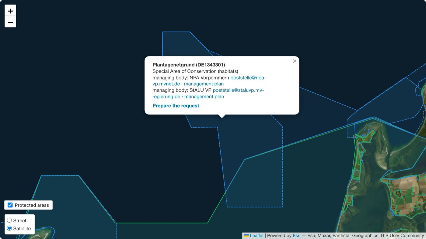
Plantagenetgrund, Germany: the data is complete. Managing bodies, email and plan link are there, and the request can be prepared.
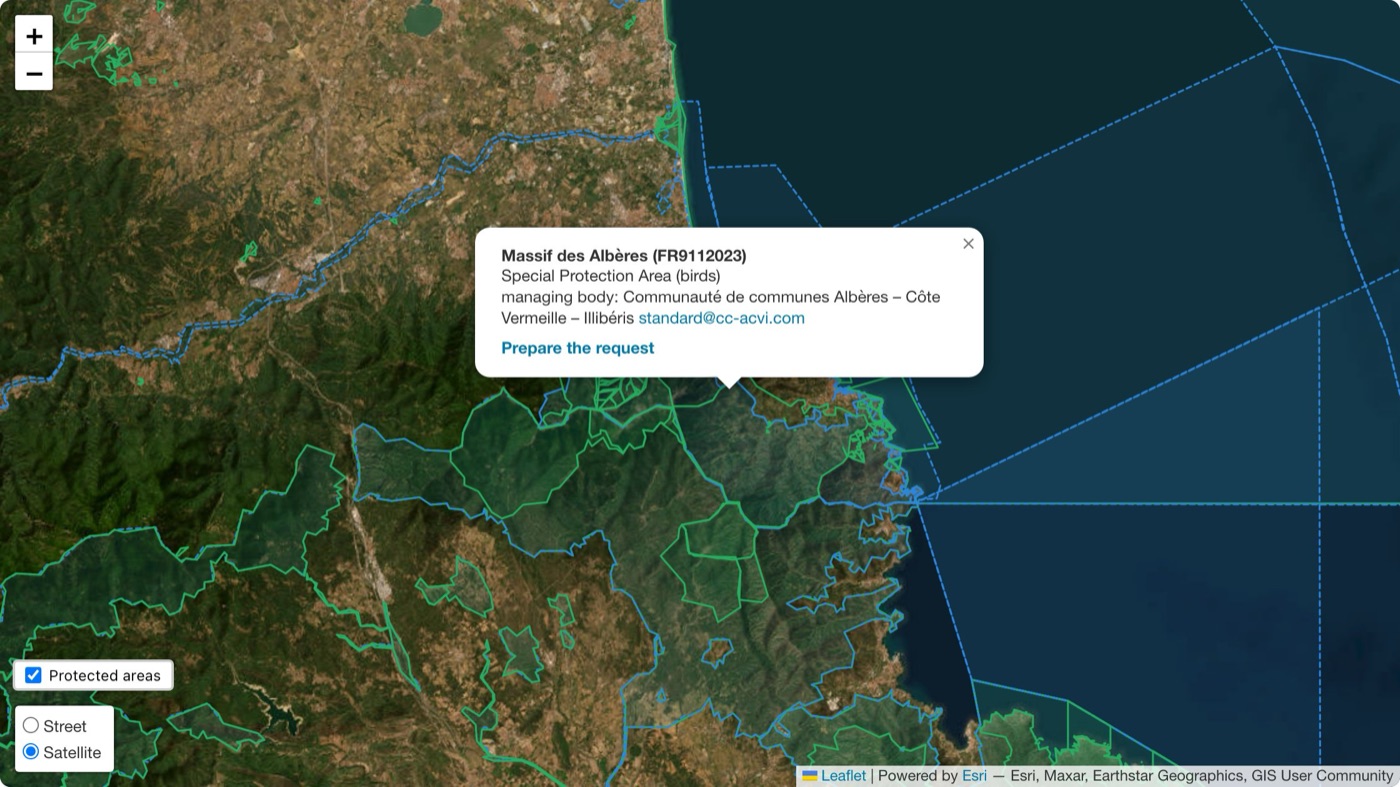
Massif des Albères, France: the plan link in the official database opens a "page not found", so Dronetrake does not show it. The email is there, and the request can still be prepared.
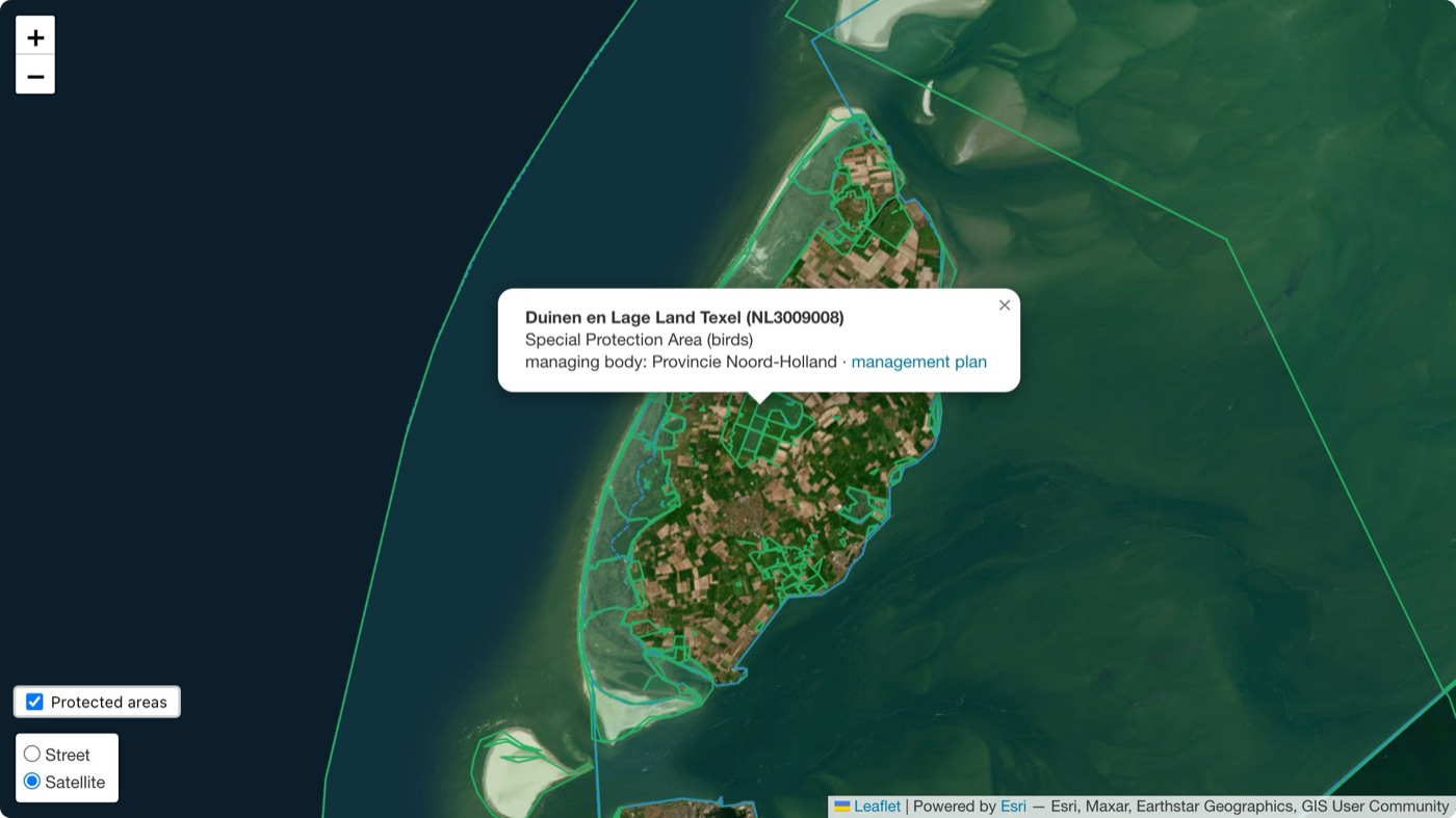
Duinen en Lage Land Texel, the Netherlands: the plan link opens, but the official database gives no email for the managing body, so the request cannot be prepared from the map.
A union of European jungles
The first survey found a common format that each State publishes as it likes. This one finds the same with parks and reserves. The regulation is European, the protected areas are European, the Natura 2000 network is European, and yet what a pilot sees before take-off depends on the country, and often on nothing at all. Drone zones and protected areas now belong to the same union of European jungles. Europe's credibility on drones gives way on more than one front at once, and a continent that does not publish its own rules in a form people can use ends up living by rules written by others, instead of setting its own.
Country by country
| Country | On the drone map | How, and the legal basis | Source |
|---|---|---|---|
| Albania | no | no UAS zone map; the authority only warns against zones near airports and those it restricts | https://www.aac.gov.al/avione-pa-pilote-drone/ |
| Austria | no | law only, in each Land's nature protection act; dronespace.at: "Naturschutzgebiete sind derzeit nicht im Austro Control Dronespace System abgebildet" | https://www.dronespace.at/geo_zonen/allgemeine_informationen |
| Belgium | no | law only: the Flemish Nature Decree, art. 35 §2, 12°, bans low-level overflight of nature reserves; Droneguide had no nature category on 10 September | https://map.droneguide.be |
| Bosnia and Herzegovina | no | no BHDCA zone map; the rules ban flying over military sites and zones | https://www.bhdca.gov.ba/index.php/hr/dron |
| Bulgaria | no, in practice | file with 881 zones; its 4 NATURE zones are Sofia water-supply sites |
https://www.caa.bg |
| Croatia | no | park regulations only, for example Plitvice; the official 2023 presentation of UAS zones shows airport zones only | https://www.crocontrol.hr/app/uploads/2023/10/2.-UAS-zemljopisna-podrucja-operativna-primjena-Toni-Zlopasa-HKZP.pdf |
| Cyprus | no | archived copy of the file of 01/01/2026: 144 zones, none NATURE |
https://drones.gov.cy/geo-zones-file/ |
| Czechia | yes | binding GeoJSON: 2,796 zones LKR318A/B/C for national parks, small protected areas and protected landscape areas (Act 114/1992) | https://aim.rlp.cz/?lang=cz&p=uas-gz |
| Denmark | yes | separate nature file and green zones on the map: "De grønne zoner på kortet visualiserer Natura2000-områder"; permit from the Danish Civil Aviation and Railway Authority (BEK 1649/2023, §14) | https://www.droneregler.dk/dronezoner/vejledning-til-dronezoner |
| Estonia | yes, as information | file: 31 "FAUNA" zones out of 235, with no restriction, valid from 1 April to 30 November | https://utm.eans.ee |
| Finland | no | law only, with rules set by Metsähallitus for State land; file with 731 zones, none NATURE |
https://www.metsa.fi/luvat/droonien-kaytto-valtion-mailla/ |
| France | announced | the Géoportail map covers the airspace order only; biotope and habitat protection zones "seront prochainement intégrées" | https://www.geoportail.gouv.fr/donnees/restrictions-uas-categorie-ouverte-et-aeromodelisme |
| Georgia | not verified | the GCAA UAS portal "will be available soon"; the protected-area layers on airspace.gov.ge are empty | https://uas.gov.ge/EN |
| Germany | yes | file (DIPUL GeoJSON and ED-318): nature reserves, national parks, Habitats Directive and bird protection sites; flying needs the nature authority's consent or, outside national parks, four conditions together, one of them a height above 100 m (§21h(3) no. 6 LuftVO) | https://www.dipul.de/homepage/en/information/geographical-zones/legal-basis/ |
| Hungary | no | law only: restricted airspace must be designated over protected areas at the nature authority's request (Act LIII of 1996, §35); none of the 42 ENR 5.1 areas is a nature area | https://ais-en.hungarocontrol.hu/uas-airspace-restrictions |
| Iceland | no | law only: drone use in protected areas needs a permit from the Nature Conservation Agency; the drone map links to park rules only as external pages | https://island.is/en/drone-map |
| Ireland | no | file of 10/09/2026 with 85 zones: 46 air traffic, 32 sensitive, 7 other, 0 nature | https://www.iaa.ie/general-aviation/drones/uas-geographic-zones |
| Italy | partly | d-flight file: 313 NATURE zones out of 4,627; most national and Natura 2000 areas are missing |
https://www.d-flight.it |
| Lithuania | not verified | the authority's site blocks automated reading; the law lets ornithological reserves ask for a prohibited zone, which does not show whether the map carries them | https://ltsa.lrv.lt |
| Luxembourg | no | file with 47 zones, none NATURE; "only the UAS geographical zones shown on https://g-o.lu/uas are legally applicable" |
https://dac.gouvernement.lu/en/drones/geozones.html |
| Moldova | not verified | the only zone map found, uas.md, belongs to a private company, and none of its categories is environmental | https://uas.md/instructiuni |
| Montenegro | no | the CAA page sets conditions for the Podgorica and Tivat control zones only; its rulebook has no nature category | https://caa.me/me/bespilotni-vazduhoplovi |
| Netherlands | not verified | the government's ED-269 file has 743 zones and none NATURE; the page bans flying over "sommige Natura 2000-gebieden", decided by the province or site manager; the maps could not be read |
https://www.rijksoverheid.nl/vraag-en-antwoord/drone/waar-mag-ik-vliegen-met-een-drone |
| Norway | yes | files ED-269 and ED-318 of September 2026: 3,470 NATURE zones out of 4,341, with the Norwegian Environment Agency as the authority |
https://dronesoner.no |
| Poland | yes, on the map | DRA-R zones over national parks on dronemap.pansa.pl, with the park director's consent (Aviation Law, art. 124), checked on Kampinos; a public ED-269 file is not confirmed | https://kampn.gov.pl/loty-dronem |
| Portugal | yes | file: 185 NATURE zones out of 358; the ANAC page lists the environment among the reasons for zones |
https://www.anac.pt/vPT/Generico/drones/zona_proibidas_condicionadas/Paginas/Zonasproibidasoucondicionadas.aspx |
| Romania | no | ROMATSA file with 1,272 zones, all restricted, and no nature field | https://flightplan.romatsa.ro/init/static/zone_restrictionate_uav.json |
| Serbia | no | law only: an order of 2020 requires CAD permission and the site manager's consent over certain protected areas; the CAD web platform is "coming soon" | https://cad.gov.rs/strana/23311/ |
| Spain | yes, on the map | ENAIRE Drones layers for protected natural areas and special protection areas for birds; AESA reads RD 1180/2018, art. 19, as requiring the manager's authorisation | https://www.seguridadaerea.gob.es/sites/default/files/UAS-OPS-DT01_v7_Zonas.geograficas.UAS_.pdf |
| Sweden | no | law only (Environmental Code, chapter 7); the LFV drone map: "Dessa områden anges inte på drönarkartan"; its ED-318 file has 62 zones, none NATURE |
https://daim.lfv.se/echarts/dronechart/ |
| Switzerland | yes | file: 763 NATURE zones out of 1,222 |
https://data.geo.admin.ch |
| United Kingdom | no | law only (Wildlife and Countryside Act 1981, s.1 and s.28P, and local byelaws); flying "may be restricted at some Sites of Special Scientific Interest", and NATS maps only flight restriction zones and ENR 5.1 | https://www.caa.co.uk/drones/open-category/drone-code/where-you-can-fly-points-3-to-9/ |
What could not be fully verified
Georgia, Lithuania, Moldova and the Netherlands: see the table. Belgium: the Droneguide categories could not be read again on 13 September. Croatia: the current AMC map was not read. Cyprus: the authority's page now asks for a captcha, so we counted the archived copy of its latest file. Italy: the file needs an operator account, so we counted the version of 8 September. Poland: the consent rule was checked on one national park, Kampinos. France: whether the cores of national parks appear on the map could not be confirmed. Iceland: the map layers are rendered in JavaScript. United Kingdom: the AIXM dataset was not read byte by byte.
Method
Two routes, both dated. Where a downloadable file exists, we counted the nature zones in the file itself, on 10 September 2026 and again on 13 September 2026 wherever the file could be downloaded without an account. For the other countries we read the authority's page or map and the national law that restricts drones over protected areas. Where a source would not open, or did not prove the point, the answer is "not verified", never inferred.
The re-check of 13 September changed six results. Norway moved into the file group. The Netherlands, Lithuania and Moldova moved to not verified. France moved from partly to announced, and Serbia, whose new decree could not be found on an official page, to not at all.