
This is the first edition of the Dronetrake newsletter. Once a month, what changes for people who work with drones: from the data we keep up to date and the news we read every day in several languages.
1. UAS zones and protected areas
In September we checked how some thirty European countries publish their UAS geographical zones: eleven published a usable file, and on 13 September Denmark made it twelve by changing its licence. Unmanned Airspace reported the survey on 9 September. Read the article
Then the second map: do national drone maps show nature reserves and parks? Of 32 countries checked, seven put protected areas in the file, two on the map only, one partly and seventeen not at all. France has announced them, and four could not be verified. The second map
The Dronetrake map now shows the zones of 10 countries, Denmark included.
2. Rules and authorities
- EU — mandatory occurrence reporting. Implementing Regulation (EU) 2026/1821, published in the Official Journal on 28 July, amends the list of civil aviation occurrences that must be reported, adding UAS and U-space occurrences. EUR-Lex
- Belgium. The DGLV has gathered in one document the rules, assessment criteria and practice for specific-category applications: SORA, ConOps, operations manual, emergency response plan, and a tool to calculate the operational volumes. DGLV guidelines
- Germany. The Luftfahrt-Bundesamt has published a guide to writing the LUC Manual, for operators applying for or holding a Light UAS Operator Certificate. LBA guide (PDF)
- Ireland. The IAA has prosecuted a drone pilot who flew in restricted airspace and posted the videos online; the court ordered €2,000 towards the IAA's costs. The IAA reminds operators to check its chart and load the latest data file before flying. sUAS News, 12 September
- Italy. ENAC has published AltMoC IT-UAS-2026-002: a pre-defined risk assessment, a compliance checklist and a template operations manual for agricultural, horticultural and forestry operations in the specific category. ENAC
- Lithuania. Oro navigacija's UTM platform has replaced most email approvals for flights in controlled airspace: 419 applications in its first four months. Dronewatch Europe, 7 September
- Netherlands. Since 1 September, flight requests in the eight military CTRs go through the GoDrone app, assessed by Defence with local air traffic control; a separate NOTAM request is no longer needed. A specific-category authorisation is still required. Dronewatch, 21 August
- Poland. PANSA has opened 10 local UAV competence centres with designated airspace for BVLOS, long-range and heavy-UAS testing, funded with PLN 84 million from the National Recovery Plan. Unmanned Airspace, 3 September
- Slovakia. Military UAS geographical zones have moved from prohibited to restricted: civil operators can now apply to the Military Aviation Authority for a flight authorisation, with active direct Remote ID. Dronewatch Europe, 18 August
- Spain. AESA, with ENAIRE, has published a guide for applications for uncrewed operations in higher airspace (HAO), such as high-altitude platforms, in the specific category. Actualidad Aeroespacial, 31 August
- Switzerland. Electronic conspicuity with ADS-L becomes mandatory from 2027, starting with general aviation, sport aviation and free flight; drones use the traffic data in this phase, and a second phase will address them. Funding applications close on 30 November 2026. FOCA, FASST-CH
3. Events to note
From our directory, between 15 September and 31 October.
Europe
- 15–17 Sep · INTERGEO · Munich
- 16–17 Sep · The Emergency Services Show · Birmingham
- 16–17 Sep · UNVEX · San Javier (Murcia)
- 16–18 Sep · RemTech Expo · Ferrara
- 21–25 Sep · IMAV · Strasbourg
- 22–25 Sep · WindEnergy Hamburg · Hamburg
- 28–29 Sep · UAV Technology · London
- 29–30 Sep · DroneX · London
- 6–8 Oct · Airtaxi & Drone World Congress · Genoa
- 6–8 Oct · Fruit Attraction · Madrid
- 6–11 Oct · ICAR, International Commission for Alpine Rescue · Innsbruck
- 7–8 Oct · Drone Security Expo · Kraków
- 7–9 Oct · UAV Show · Bordeaux
- 14–15 Oct · DRONTEX 26 · Piešťany
- 14–16 Oct · eVTOL Insights Europe Conference · Toulouse
- 18–21 Oct · DroneTech Poland · Toruń
- 31 Oct–6 Nov · International Conference on Forest Fire Research · Coimbra
Rest of the world
- 23–25 Sep · Congreso Internacional de Drones · Tucumán, Argentina
- 25–27 Sep · Expodrone Monterrey · Monterrey, Mexico
- 5–6 Oct · Harmonized Skies (GUTMA) · Tokyo
- 13–14 Oct · UAS Summit & Expo · Grand Forks, USA
- 19–23 Oct · Wildland Fire Canada · Saskatoon, Canada
4. One country a month: Germany
- 37 drone schools in our directory. Schools in Germany
- 23,529 protected areas on the map: 5,203 Natura 2000 sites and 18,326 national areas. Protected areas
- For operators working towards a LUC, the Luftfahrt-Bundesamt guide above.
- On the calendar: INTERGEO (Munich, 15–17 September) and WindEnergy Hamburg (22–25 September).
5. From Dronetrake
Protected areas, with the body that manages each one
The map holds 27,173 Natura 2000 sites and 142,360 nationally designated areas in 38 European countries, on street or satellite imagery. Each area gives its name, its designation, the IUCN category where there is one and the managing authority; bird protection sites also give the breeding period. For 16,003 sites the official data includes the managing body's email: with an account, Dronetrake prepares the authorisation request in that body's language, and you send it from your own mailbox. Open the map
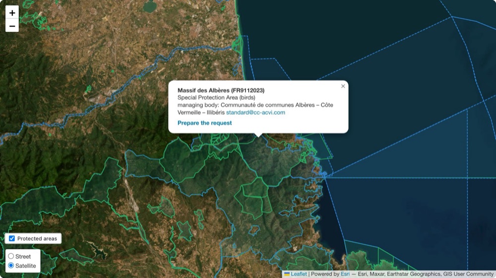
Massif des Albères, France, on satellite imagery: the designation, the managing body with its email, and the link that prepares the request.
Continuous coverage: how many hours a drone stays in the air
A live stream that runs all afternoon, a search that goes on into the evening, a site to watch for a whole shift: Dronetrake simulates the operation minute by minute, from your drones, batteries, charging slots, cooling and charging times. It shows how long coverage lasts before the first gap, whether the bottleneck is charging or batteries, and what to add. Two drones with six batteries, 25 usable minutes each, 90 minutes per charge and two charging slots: the first gap opens at minute 200 of an eight-hour day, and two more slots close it. When the logbook has flights, each battery's real flight time replaces the rated one, and a plan opened from a mission is saved on the mission. How it works
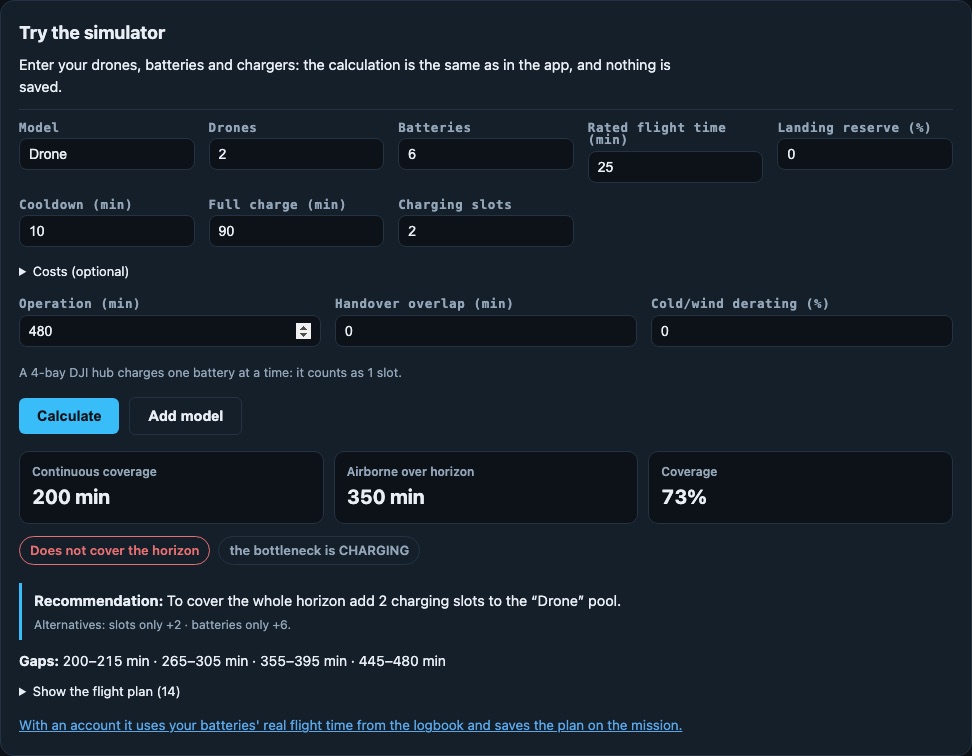
The simulator is now on the public page, with no account. With the example above: 200 minutes of continuous coverage, the gaps after that, and what to add.
Flight plans straight into DJI FlightHub 2
A flight plan that is ready in Dronetrake goes with one click into the route library of a FlightHub 2 project, with the drone model declared for Matrice 30/30T, Mavic 3 Enterprise, Matrice 3D/3TD and Matrice 4T. FlightHub 2 then sends its events back to Dronetrake with a signature, and the upload is confirmed when the event arrives. The connection is set once, under Business, with the organisation key.
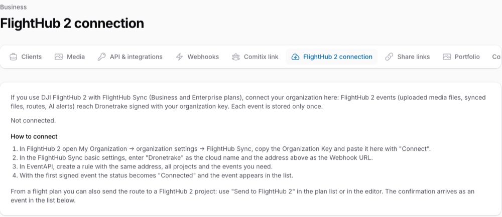
Business → FlightHub 2 connection: the organisation key goes in once, then “Send to FlightHub 2” works from the plan list or the editor.
Denmark on the map
On 13 September Trafikstyrelsen's zone files carried a new licence: «Data kan frit anvendes med kildeangivelse», free to use with attribution. The Danish zones are now in our public dataset: airports and helicopter pads, security-critical sites, attention areas, and Natura 2000 areas while their protection period is active. They are read again every morning, and each one names Trafikstyrelsen as its source. Pre-flight check
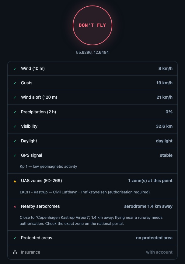
The pre-flight check at Copenhagen Airport: the Kastrup zone from Trafikstyrelsen, next to weather, GPS signal and the nearest aerodrome.
Ten languages
Romanian and Greek arrived on 12 September. The app, the website and the user manual now speak Italian, English, German, French, Spanish, Dutch, Polish, Portuguese, Romanian and Greek, and the app follows the language of the organisation, so each team works in its own.
Two directories
323 drone events around the world — fairs, congresses, competitions, agriculture, security — by category, type, area, country and month, each with its dates and organiser. And 3,788 drone schools in 94 countries, country by country. Events · Schools · Our surveys in the press room

Drone schools in Germany: each school with a preview of its website, and a badge when it is in the authority's register.
— Dronetrake Press Team